Monday, May 30, 2022

May 28- 30 McClellanville, SC to Cape Lookout, NC

With our depth sounder working once again and a very light breeze out of the southeast we left out of Five Fathoms Inlet to continue northward. Despite the name there are shallows at the mouth that can make this a very rough inlet in the wrong conditions, but today was not that.  Our goal had been to bypass the ICW between Morehead City NC and Norfolk VA by sailing outside around Cape Hatteras, but the weather had other plans for us. So we headed towards Cape Lookout, just outside Morehead City.  Cape Lookout came highly recommended so we were looking forward to the visit.

Our 180 mile ocean crossing was a combination of sailing and motoring as the winds were very light and it took about 30 hours. During one night watch shift on a moonless night, a really bright meteor about 20 degrees above the horizon came whooshing by that was pretty cool to see. Distant lightning flashes off to the east at a distance that were not of concern, also added some interest to the night sky. With plenty of free time to kill while on autopilot, we discovered through reading that Memorial Day weekend is about the busiest, most crowded time at Cape Lookout. As we approached on Sunday afternoon, the earlier information was confirmed seeing the large number of boats and people along this national seashore. We had a pleasant surprise that there was still plenty of space to anchor. Even better, by sunset, the beach cleared out of the day trippers, leaving the 15 boats on anchor for the night to enjoy the solitude.

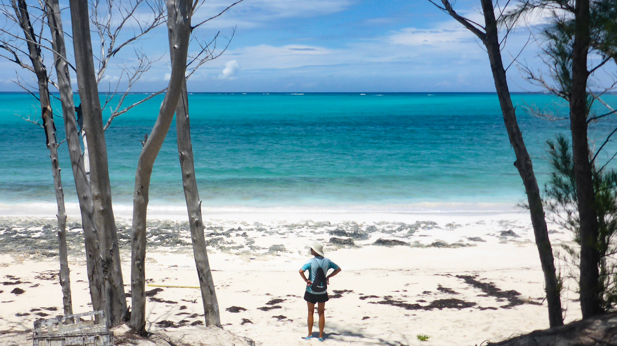
Memorial Day Monday, we dinghied ashore to investigate the lighthouse that had an interesting diamond pattern painted over its entire height.  We didn’t get very far before we met fellow cruisers Chris and Mandy from s/v Bedouin who were also moving north after a winter in the Bahamas. Deciding that we had much more to discuss, we invited them to join us later for a drink aboard Juno. The lighthouse was closed but lighthouse enthusiasts and temporary keepers/docents, Jack and Toby from PA, were happy to share their knowledge about how past storms have reshaped the landscape. The also told us the black diamond pattern indicated the north-south facing side, and the white faced east/west.  This enabled mariners to better determine their position during daylight. We crossed the dunes to the eastern most shore where the many miles of the sandy outer banks extend northwards. There we enjoyed a swim in the warm, although less clear waters, and a picnic. We really enjoyed Cape Lookout and were glad to have made this stop.

Watching the weather with the first tropical storm of the season (Agatha) threatening to impact the central east coast up to Cape May, NJ, we decided to head up the ICW to Norfolk, VA and likely up the Chesapeake, down the Delaware to Cape May rather than to go around the outside as the latter route route would involve a lot of motoring given the light wind forecasts and we didn’t want to be anchored in Cape May in case the tropical storm hit. However, our new friends Chris and Mandy  (s/v Bedouin) were planning on taking the outside route to the Chesapeake so their progress would give us something to track in the coming days.


Heading out Five Fathom River on a tranquil morning

Temporary lighthouse keepers and docents Jack and Toby

Looking north (or is it south?) at the Cape Lookout Lighthouse

The quiet of the anchorage after the day-trippers have gone.

Friday, May 27, 2022

Friday May 27 Thunderstorms Knock Out Our Depth Sounder

Thunderstorms arrived about 9 am as forecast with much wind from the SE and lightning but by 10 am the storms had moved on so we thought it safe to haul anchor. With a SE wind and storms lingering around, we decided to stay inside on the ICW which meant a day of motoring. But once we got started, we quickly realized our depth sounder wasn’t working. This wasn’t so serious as to stop us from making some distance but we stopped when we got to McClellanville, SC  about 20 miles to the north, to see if we could fix the depth sounder. Harry reached out to the manufacturer for assistance and given the device’s age, we were advised that the unit had probably reached the end of its life.  In desperation, Harry also sent an email to fellow Beneteau 423 owner Steve Shanck to see if he had any suggestions for what to do and Steve suggested we do a factory reset. But before doing the factory reset, since it was now about 4:45pm on a Friday before a holiday week-end, Harry placed a rush order for a brand new depth sounder so that we would minimize delays while we waited for the new unit to arrive. Then came time to do the 10 minute factory reset on the depth sounder and like magic, it worked! Steve Shanck diagnosed our problem perfectly and for no added expense save for a few beers next time we see him.


Other than the diesel engine, the ICW can be quite peaceful.

Why it's highly desirable to have a depth gauge on the ICW

Thursday, May 26, 2022

May 25-26 At Sea Between St. Augustine and Charleston (Capers Inlet), SC

Winds for this 36 hour offshore leg started with 10-15 knots out of the SW. We left St. Augustine 8 am on Wed under sunny skies and raised both sails and used our autopilot to steer 23 degrees north. Our sail on Wednesday was uneventful and our speed ranged between 4.5-6.5 knots. Thursday morning the winds died so we motor-sailed off and on much of the day since we wanted to reach Charleston before nightfall. When we passed 20 miles off of Savannah, we had to snake our way through about 20 tankers/cargo ships sitting on anchor awaiting their turn to enter the port. As we approached Charleston harbor around 5 pm, a storm developed to our southwest hitting just as we got in the harbor. We dropped our anchor close to Fort Sumter with the intention of staying the night but found it too rolly. Knowing that the Charleston City Marina was full for the night, we felt our next best option for a quiet anchorage was 7 miles north on the ICW at Caper’s Inlet. We had to wait a short while before heading north on the ICW as a bascule bridge’s next opening wasn’t until 6 pm. Once through, we motored north and dropped our anchor in quiet, marshy, Caper’s Inlet where we had stayed on our way south six months ago.


Sunrise and freighters off of Savannah

Contrast of the blue ocean and the Charleston Harbor estuary
 
 
The approaching squall as we pass Fort Sumter


Saturday, May 21, 2022

May 21-24 St. Augustine, FL- Hot, Humid, Stormy Weather & Vang Repairs

Threatening thunderstorms with hot and humid weather continued Saturday & Sunday making tasks such as refueling and grocery shopping sweaty affairs. We each snuck a freshwater shower while we refueled Juno (25 gallons at $6/ gallon) at the Comachee Marina. The showers helped cool us down for a short while. Grocery shopping was a special treat at a Publix as we were thrilled to have such a large choice of fresh produce after living without so much variety since arriving in the Bahamas. The air conditioning was also very much appreciated as the humidity outside felt like it was 99%.

Sunday afternoon, we received word that a mooring was available at the city marina so we hustled to pick one up and while ashore, threw in a few loads of laundry before heading out to Catch 27 for dinner. When we returned to the marina, the laundry room with our bed sheets was locked since it was after nine pm. Fortunately we got hold of a security guard who unlocked the door so we could retrieve our sheets and laundry.

Monday and Tuesday each began around 6:00 am when the nearby drawbridge announced over loud speakers to announce it was about to open. With a major city on our doorstep, we took advantage of the access it offered to many resources.  Harry set off ¾ of a mile on foot to the Ace Hardware to refill one of our propane tanks and returned via Uber with a few bagels, the propane, and white wine for Sarah. He also tracked down a transmission fluid dipstick to replace ours which had broken.  Harry then set about repairing the failing rivets in our boom vang that he noticed on our passage from the Bahamas. After consultation and some parts from Jan Brandt, another 423 owner in St. Augustine, and additional consultation with cruising acquaintances and professional riggers Suzanne and Dobbs of Walden rigging, Harry decided on the replacing the rivets which meant a trip to Harbor Freight to purchase a riveting tool. We are definitely spoiled in the US.

With the right tool, Harry completed the vang repairs in time to invite Heidi and Christian from s/v Aurora for cocktails. We enjoyed getting to know them as they were from Boston, were Great Loopers (refers to transiting the Great Lakes to the Mississippi River and back to New England), and they had anchored with us our last day at Double Breasted Cay in the Bahamas. During our conversation they told us of the water spouts that we narrowly missed by leaving the Bahamas a day ahead of them. 


Food, glorious food - and air conditioning!

Thursday, May 19, 2022

May 19-20 Our Crossing to the US Ends With Much Stress

As forecast, a southerly wind picked up last night at 1:00am, waking both of us up as Juno was bouncing so heavily there was no way we were going to get sleep. So we turned on the lights and considered sailing off for Florida at 1:30am since there was a good wind rather than waiting until daybreak when the winds were forecast to be too light to sail. We almost decided to leave in the middle of the night but unfamiliarity with navigating the shallows in the dark kept us from leaving. So we each relocated to less bouncy but still uncomfortable sleeping quarters in the living area of the boat for a little more sleep before dawn.

Dawn came, winds died, and we ended up motoring out Walker’s Channel saying goodbye to the crystal clear turquoise waters of the Bahamas. The motor stayed on all day and only after dinner, around 6:45 pm, was there enough wind to raise both sails and sail. Winds blew 15-17 knots SE moving to S all Thursday night.  We got a 1.5 -2knot push northwards once we entered the Gulf Stream around 10pm, helping augment our 4.7-5.7 speed through the water. Lightning could be seen to the south, but too far away to be much of concern. Harry however was concerned by two rivets that connect the boom vang to the boom which had come loose. He was able to secure the boom vang with some line as a stop-gap measure for the duration of our crossing. On our first trip Harry also had to repair the boom vang on our return to the US. Hmm?

Perhaps even more troubling than the vang was a large storm coming up from southern Florida and the Bahamas. (We later learned that this storm spawned several waterspouts in the Bahamas.) Harry thought that if we were to encounter a squall while in the Gulf Stream, we might find that the sea conditions would get very uncomfortable very quickly. Thus, we made the tough choice to exit the Gulf Stream and head for St. Augustine, FL about 95 miles away over Beaufort, NC. It was a very hot and humid day, motorsailng much of the way to maintain a decent speed in order to get to St. Augustine before the squalls were to arrive. Around dinnertime, we had 25 miles to go, but a line of squalls was approaching from the south so we took down the sails. It turned out we dodged the worst of the rain and lightning but two hours later, the winds picked up to 25-30 knots and the seas got bigger, followed shortly with rain and lightning visible in the distance.  We were now only 10 miles from the St. Augustine inlet and stepping up our speed so as to get in to the harbor. 

One minor detail Harry mentioned as we were approaching the entrance to the harbor- we didn’t have the navigational chip for Florida in our chart plotter stationed at the helm so we would have to navigate using the iPad. Normally this isn’t a problem but it was now about 10 pm - dark, raining, and the wind and seas were still up and we were entering a channel that was unfamiliar to us. Sarah with the better eyesight took the helm while Harry held the iPad and called out navigational instructions. This tense situation only got more intense when out of the corner of Sarah’s eye, an unlit and uncharted buoy appeared within 10-15 feet of the boat. Some quick last second maneuvering avoided leaving red paint on Juno. Unfortunately this near encounter with an unlit buoy happened not once, but twice on our entrance into St. Augustine Harbor! We were feeling so lucky we didn’t end up hitting either of the unlit marks. Our radar should have showed these coming but with the heavy rain blurring out the radar targets, focusing on the iPad, and a bit of sleep deprivation Harry had forgotten to adjust the radar to eliminate the rain.

Once inside the harbor, the seas calmed down but now we had to find a place to anchor in the dark. Harry wanted to anchor off the old fort in the heart of the town so we headed about a mile down the ICW. However with all of the city lights, the strong currents in the ICW, and a very small but crowded anchorage area, it made maneuvering the boat and finding a spot in which to anchor too much for tonight. So we cut our losses, retraced our steps and headed back up the ICW away from town, about 3 miles. There we found a safe spot to anchor around midnight, and climbed right into bed, exhausted from the late hour and from all the stress, storms, and near misses.


The last of the Bahamas - for a while
Walker's, Little Walker's, and Sit Down Cay

Sarah lowers the Bahamian courtesy flag out in open waters.
Satellite view of the storm headed our way

Diverting to St. Augustine

Wednesday, May 18, 2022

May 18th Last Day in The Abacos at Double Breasted Cay and a Final Check on the Weather

We had plenty of sunshine but no wind for our last day in the Bahamas so we had to turn the engine on to get from Hawksbill to Double Breasted Cay, one of the most northwestern cays in the Abacos. We had seen photos of this unusual shaped cay that resembles the letter H where the crossbar connecting the two parallel lines is a a tiny island surrounded by sand rather than a crossbar, and not a soul is in sight, so we were eager to find out for ourselves. We arrived just after lunch and were the only boat around, so we set off in the dinghy, explored some mangroves, and then the tiny sandy island that we walked completely around in a matter of 15 minutes. We hung out in the shallows on the sand bar that extends from the tiny island and then rinsed off the salt water aboard Juno and in the process, realized we had only 30 gallons of freshwater left aboard the boat. That would be the last fresh water shower until we reached the US. At dusk, one other sailboat named “Aurora”, also en route back to Boston, arrived and had a little trouble getting their anchor to hold. With a little input from Harry communicating over the radio, they finally succeeded.

We plan to leave the Bahamas tomorrow morning, motoring initially until a southerly wind fills in when we hope to sail the remaining distance northward. The tropical storm in the Gulf of Mexico (Alex) whose movement several days ago was uncertain but potentially a threat to our travels, now appears to be following another course such that it is no longer of significant concern. Thunderstorms however are forecast for the next several days so we have fingers crossed and are hoping for the best. For our last night on anchor, winds are forecast to come out of the south. Unfortunately this does not bode well for a restful night’s sleep as Double Breasted Cay offers no protection in a southerly wind - once again the price we have to pay for being in paradise.
 

No wind but still beautiful headed to Double Breasted

Our exposed anchorage at Double Breasted

The mangroves

Exploring at low tide


Tuesday, May 17, 2022

May 17: We Paid the Price for a Few Hours at Allans-Pensacola

Allans-Pensacola is one of the remote cays we had wanted to revisit as it had been a favorite of ours on our last trip. We were one of three boats visiting the cay whose anchorage is exposed to winds with a southerly component. Last night, the light forecast winds had a southerly component but by 1am had built to 12-15 knots, making sleeping in our bed at the front of the boat untenable.

The sleepless night was soon forgotten when the sun came out and we headed ashore to one of our favorite beaches in the Abacos. One thing that is unique to this beach is the “signing tree” where passing cruisers adorn a tree ( now several trees) with their homemade boat signs. We searched high and low for the sign we had left in 2019 but concluded hurricane Dorian must have gotten the best of it. So, we took out a piece of driftwood we had been saving for just this purpose and created a new Juno 2022 sign. This time, we chose to place our sign higher up in the tree so that it wouldn’t get washed away with a storm. We enjoyed a nice picnic lunch on the beach which we had all to ourselves and a swim before returning to the boat and seeking out a more protected anchorage at Hawksbill Cay so as to avoid another sleepless night. 


Disappointment that Dorian had claimed our boat sign from 2019

No worries. We have our mark again.


No, those are not Harry's legs

Ready for dinner at Hawksbill Cay


The Juno crew always eats well onboard

Monday, May 16, 2022

May 16: A Lunar Eclipse, Red on the Radar, Weather Routing, and Our Customs Check-Out

Yesterday we dropped our anchor off of Powell Cay. That night as we went to bed we set an alarm to wake up around 11:20 pm for the lunar eclipse. We had a hazy sky so it wasn’t the clearest it could be but we saw enough of the earth’s shadow covering the moon to sustain us until the next occurrence and went back to sleep. The next morning our plan for the day was to explore Powell Cay but an early morning check on the weather revealed a large red blob of rain on the radar coming our way. Because our anchorage left us very vulnerable to the approaching stormy weather, we sought better protection. So around 7:30am we left Powell Cay and motored southwest 2.5 miles towards for an anchorage off of Cooperstown on Great Abaco. We had some difficulty getting the anchor to hold as the bottom wasn’t very sandy but thankfully the anchor bit into the bottom just before the rain and lightning arrived around 10:00am. The storm wasn’t bad and it gave us time to study long term weather forecasts for crossing back to the states as our Bahamas cruising permit expires next week and we have to be north of Florida by June 1st for insurance reasons. 

Unfortunately, the “inclement” (e.g. pop-up thunderstorms) seems to be here to stay for the foreseeable future making a 450 mile sail to Cape Hatteras, NC a risky proposition. Given the forecasts for the coming 10 days, we decided a departure in the next three days for northern Florida, while only 200 miles to the north, looks to be our best (least likely to encounter a storm) option for exiting the Bahamas. With a plan in hand for departing the Bahamas, one final task we had to tend to before leaving is the official clearing of customs which can only be done at a few select locations, one of which is Spanish Cay about 5 miles northwest of Cooperstown. 

So with our exit strategy in hand, we set off to Spanish Cay just after lunch and the morning storm had cleared out for our customs clear out with the Bahamian government officials. Our clear out was a smooth process as Spanish Cay was very quiet with only two other boats in the marina.  Most of the Cay is private so there was no exploring to be done while ashore. 

Once our exit from the Bahamas was documented, we were supposed to leave ASAP but we had a few last remote cays we had wanted to visit. So we ended up motoring 2 hours from Spanish Cay to reach Allans-Pensacola as the winds were too light to sail.

Settling in for a nice night with hopes of exploring tomorrow morning

 
Spanish Cay Marina and customs office

Unfortunately you can't smell the stunning
fragrance of this Frangipani

Sunday, May 15, 2022

May 14 &15 Crab & Nunjack Cays: The Best Art Trail Walk

While we were anchored off of Crab Cay on May 14, we couldn’t go ashore as the cay itself is a nature preserve. Aside from a small sandy beach exposed at low tide (where we saw a sea hare https://m.youtube.com/watch?v=0evPX7ycMyw), you have to go to nearby Nunjack Cay if you want to do some walking. Before visiting Nunjack Cay, we first did some exploring of the mangroves off of Nunjack with the dinghy, spotting many small sea turtles in the shallow waters of the mangroves. When the sea turtles see us coming, they flap their front flippers and quickly “fly” away.  Once we were ashore on the eastern end of Nunjack Cay which is undeveloped save for a few homes, we found a most creative “art trail” to walk. What is an “art trail” you might ask? Well, it is a path where people have repurposed household, discarded, and organic items into art. It involves a lot of creativity, ingenuity, and resourcefulness on the part of the artist as glue and nails are not easy to come by. When finished, the artist displays their masterpiece in the woods along the footpath for passerby’s to enjoy. We encountered one other art trail on Stocking Island in the Exumas, but this one was much longer and more heavily decorated and made for a most enjoyable walk.

A nearby resident has provided this swing for all to enjoy

One of 50 artistic creations along the art trail

 Sunday, May 15th, we moved Juno to the northwestern tip of Nunjack but not before we got caught in a heavy rain storm. We almost had the anchor down when the dark cloud overhead let loose and rain came pouring down. Thankfully the  rain shower didn’t last long and because our dinghy acts like a big bucket, we took advantage of all the freshwater that had collected in the dinghy to wash some dirty laundry. Once ashore, we saw the numerous sting rays that come right up to the beach and which proceed to swim right over our toes. Many people come to this spot just to see and feed them so they hang around the area. Unfortunately for them, we were the only boat around and we didn’t have any food to offer them. We had some trouble finding the walking trail that leads into the thick brush but we eventually found it, hiked to “da beach” on the south shore and then to the “ocean beach” on the north side of the island where we ended up at a newly constructed shelter that provided a welcomed break from the sun.. After a swim, we walked the expansive deserted beach back around to our anchorage, where a few other day trippers had arrived. The new arrivals were locals - one couple had come to harvest some snails that could be found on the rocks. The other was a large extended family, that had come to enjoy a picnic and the beach. 

Not to be outdone, Sarah shows off her navigating skills
 
The Ocean view at the end of the path

Yet another beautiful Bahamian beach at Nunjack Bay


Friday, May 13, 2022

May 13 Unsettled Weather and Coconut Bread on Green Turtle Cay

Today was cloudy and squally. The first of the rains arrived at 3:30 in the morning but we seemed to escape the lightning and thunder. After breakfast, all was quiet with winds 5-10 knots out of the SE. We didn’t let threatening skies deter us from going ashore and so we walked the little town center on Green Turtle Cay town and met a most friendly man, JR, who had lived on the island his entire life and who guided us to “Sid’s” for fresh bread. We had a choice between plain and a coconut variety of bread and bought a loaf of the latter along with a small token gift from the Bahamas. We then hiked to the beautiful Gilliams Bay Beach but as the weather was threatening rain, we didn’t have long to enjoy the beach before heading back to Juno and arriving at the boat just as the rain began. Our lunch consisted of peanut butter and jelly on white coconut bread which made for a nice twist on the usual PB & J and afterwards, we set off for Crab Cay with just a jib.

Some cool building art while headed to the beach
 

Harry seems to be onto something

Yep! He found the beach at Gillams Bay


Thursday, May 12, 2022

May 10-12 Great Guana Cay:Grabbers & Nippers Continue On

Winds moved more northerly and were a bit strong while we were at Great Guana Cay. We found some shelter from the winds just outside Fishers Bay and from there took the dinghy to Grabbers. Grabbers is a  a small beach side resort with an active bar, small pool, and beach.  It is a hangout popular with cruisers as well as those staying on the island.  We enjoyed their lounge chairs and a drink.

A walk down to “Love Beach” on the north side of the Cay revealed a storm scoured beach and Nippers,  popular seaside bar/hangout location.  While Grabbers, on the sheltered side of Great Guana Cay, will remain relatively safe from the next hurricane Nippers sits precariously atop a twenty foot rise above the beach facing the ocean. It may not be long before the sea claims it.

The island was busy with the sights and sounds of construction crews repairing and rebuilding. We lost a day ashore on Great Guana on May 11th due to rain and threatening weather, but the rain showers provided us both with enough fresh water to wash our hair in the cockpit and not use our precious on-board fresh water. It felt so good having clean hair!


Grabbers

A make-shift sun shelter

     
A view from Nipper's

Making the best of a rainy day

Monday, May 9, 2022

May 8. & 9: Treasure Cay Marina No More

Several years ago, we had stopped at Treasure Cay while chartering a boat in the Abacos with friends and  where we found a nice marina and a beautiful long crescent beach so it was an easy decision to return here, especially when the shore would give us good protection strong north-westerly winds that were forecast. While called a cay, Treasure Cay is really part of Great Abaco. We ended up spending two days here waiting for the strong winds to abate.  This gave Harry time to clean a couple of winches that were operating poorly and for us to get ashore. Ashore, we found what was left of the Treasure Cay Marina post hurricane Dorian. Sadly we found the marina and resort still laying in ruin. The swimming pool and buildings were decaying and while there were plenty of empty moorings in the harbor, we didn’t feel we could trust tying up to one since we didn’t know when they were last serviced. We were able to tie the dinghy to a dock and to walk the beautiful beach. We found the beach to still be a beautiful as in 2016 but today, with the strong NW wind, the water was covered in casuarina pine needles and a little churned up.  We got a nice long beach walk in and encountered Bahamians working to return other beach resorts and vacation homes into a state that would be attractive to tourists. 


Treasure Cay Resort in 2016

Treasure Cay after Hurricane Dorian today

Condos that are likely beyond repair

A resort that has rebuilt and is open for business

It is still one of the most beautiful beaches in the world

Saturday, May 7, 2022

Sat. May 7th: Resupply Runs at Marsh Harbour

We took advantage of being in the busiest town in Abaco today beginning with a run to Maxwell’s Market to replenish milk, yogurt, and produce. Due to the warning the other day regarding the theft of a dinghy engine in Marsh Harbour, we made sure to take our lock. We had the best intentions to lock the dinghy however as Harry was locking the dinghy to the dock, the lock slipped out of his hands and into the water. Harry wasn’t about to lose our only lock so he went back to Juno, put on a bathing suit and grabbed a mask so that he could retrieve the lock from the harbor. Fortunately he was successful in finding the lock and we then locked the dinghy and walked 1/4 mile to Maxwells and returned to Juno with a case of tonic water in addition to our groceries. 

After lunch, we then wanted to obtain some diesel and fresh water. We took three empty 5-gallon Jerry cans for diesel and 2 Jerry cans for fresh water to the Conch Marina by dinghy as it looked doubtful as to whether there was enough water to bring Juno to their dock. Emptied these into the appropriate tanks on Juno and made a second run in to refill each. Diesel was going for $7.25/gallon, water in contrast was a bargain at $0.20/gallon. 

Finally, we made one final run ashore,  and it was literally a run, to the liquor store ahead of a threatening cloud, to buy a case of mango radlers to take back with us to the states. The Bahamian beer company Kalik, makes a refreshing light beer with mango that is Sarah’s favorite. 


Harry awaits the dock hands so he can get water


Evidence of Dorian's destruction


Friday, May 6, 2022

Friday May 6th: Many New Acquaintances at Man-o-War Cay

 Several weeks ago when we met up with Dave and Wan Grabb (see April 13th blog), Wan gave us contact info for two friends of theirs on Man-o-War (MOW) Cay.Thanks to Wan, we met both friends after we dropped our anchor off MOW Cay following a short sail from Hope Town. We first met Lisa and Pete who were at their new home on Dickie’s Cay (Dickie’s Cay is 60 yards south of MOW forming a little harbor with MOW) as their original home had been destroyed by hurricane Dorian. They were busy fixing up their new home, just next door to their former home when we pulled up to their dock. After brief introductions where we also met their house guests Kim and Bob, Lisa and Pete were kind enough to show us around their new property and home. In the course of talking, we discovered shared ties to Lake Charlvoix, Michigan and a mutual acquaintance from Ann Arbor (Sarah’s former pediatrician and good friend’s father). We stayed about an hour before crossing over to MOW by dinghy. 

At MOW we walked the town that is known for the Albury family and their long history of boat building. The cay was hit very hard by the hurricane, which destroyed much of the Albury boat yard but the resilience of the local people came through. Two such individuals we chatted with who demonstrated much resilience we’re running the only two shops that were seemingly open (aside from the grocery store). Both happened to share the same last name of Albury. Joe (about 90 yrs of age) was running Joe’s gift shop and Annie (about 80 hrs old) was busy at her sewing machine making canvas bags in a well stocked but cramped shed across the street from the Sail Shop’s former location. 

We then dinghied around to the Grabb’s dock where we encountered a couple in a passing golf cart who stopped as they knew we must be the friends of the Grabb’s that Wan had informed them would be arriving. We introduced ourselves to Anne-Charlotte and Per who kindly extended us an invitation to join them at their home tomorrow for a drink. We thanked them for their kind offer and told them we were planning on moving to Marsh Harbour for the night in view of some unsettled weather coming from the south and so we would have let them know tomorrow if we thought we could return. 

We also met Neil as we approached the Grabb’s home. Neil is the local caretaker who was doing some outdoor construction work for the Grabbs, and he was busy digging a hole for a new water cistern. Down here, fresh water is a limited commodity so homes collect rainwater from their roofs and store it in cisterns for later use. Neil had been helpful to us on the phone yesterday alerting us to some shallow depths in MOW harbor. His information was partly responsible for us electing to anchor Juno off MOW rather than to use the Grabb’s mooring in the inner harbor.

We didn’t stay long at MOW due to the weather forecast but we certainly had an extra special visit while  there thanks to the Grabb’s outreach efforts.


Harry and Sarah with Lisa and Pete


Perfect timing by Per and Anne-Charlotte


A classic Albury sailing dinghy